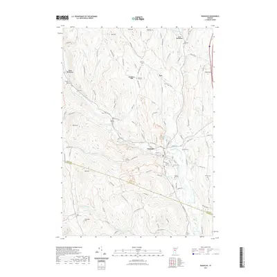
2021 Map of Randolph
USGS Topo · Published 2021About this map
Randolph serves as the central hub of this Green Mountain landscape, situated at the confluence of several vital waterways including Thayer Brook and the Third Branch White River. The settlement pattern reflects the rugged interior of Orange County, where small villages like West Braintree, East Braintree, and Peth are connected by a network of winding roads such as Braintree Hill Rd and Peth Rd. The area is characterized by high terrain like Deer Mtn and Oak Hill, with numerous small cemeteries marking the historical family footprints across the hills. Researchers will find a high concentration of burial sites including Old Church Cem, Roswell Ford Cem, and the Braintree Hill Cem, each tied to the early upland farming communities. The transition from the valley floor to the surrounding heights like Hebard Hill illustrates the classic Vermont land use of concentrated village commerce surrounded by dispersed hillside homesteads.
Find a feature on this map
113 named features on this map. Tap any name to fly to it.
Don’t see what you’re looking for? This feature index may not catch every label — zoom into the map to look around manually.
Map Details
Editions of this 2021 Randolph Map
This is the sole edition of this map. No revisions or reprints were ever made.
Other maps of this area

1915 · Rochester
USGS Topo · 1:62,500

1917 · Rochester
USGS Topo · 1:62,500

1919 · Royalton
USGS Topo · 1:62,500

1919 · Lincoln Mountain
USGS Topo · 1:62,500

1920 · Lincoln Mountain
USGS Topo · 1:48,000

1921 · Lincoln Mountain
USGS Topo · 1:62,500

1922 · Barre
USGS Topo · 1:48,000

1924 · Barre
USGS Topo · 1:62,500

1924 · Randolph
USGS Topo · 1:48,000

1926 · Randolph
USGS Topo · 1:62,500