1913 Map of Reading
USGS Topo · Published 1954About this map
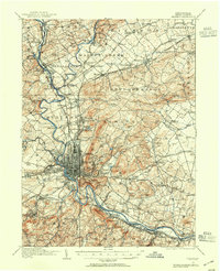
The Schuylkill River carves a path through this Berks County landscape, anchoring a dense industrial and agricultural network centered on Reading. At the time of this survey, the city is a hub of transportation, bounded by the Reading Belt Line and the Pennsylvania RR, with a grid extending toward Mount Penn and Neversink Mountain. Beyond the urban core, the map reveals a rural geography of crossroads and small industry, from Van Reeds Mill on the Tulpehocken Creek to the Friends Meetinghouse in Oley. Dozens of one-room schoolhouses, such as Oley Furnace School and Becktown School, dot the townships of Alsace and Exeter, reflecting the localized social structure of the early twentieth century. The map also captures early public works like the Antietam Reservoir and the Bernhart Reservoir, essential for the region's burgeoning growth.
Find a feature on this map
146 named features on this map. Tap any name to fly to it.
Don’t see what you’re looking for? This feature index may not catch every label — zoom into the map to look around manually.
Map Details
Editions of this 1913 Reading Map
This is the sole edition of this map. No revisions or reprints were ever made.
Other maps of this area

1889 · Pottsville
USGS Topo · 1:62,500

1891 · Pottsville
USGS Topo · 1:62,500

1894 · Reading
USGS Topo · 1:62,500

1902 · Boyertown
USGS Topo · 1:62,500

1902 · Wernersville
USGS Topo · 1:62,500

1902 · Slatington
USGS Topo · 1:62,500

1905 · Honey Brook
USGS Topo · 1:62,500

1906 · Phoenixville
USGS Topo · 1:62,500

1906 · New Holland
USGS Topo · 1:62,500

1907 · Honeybrook
USGS Topo · 1:62,500