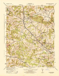
1944 Map of Reisterstown
USGS Topo · Published 1944About this map
Reisterstown and its surrounding countryside represent a late WWII-era landscape defined by institutional estates, specialized agriculture, and the Western Maryland railroad. The topography is etched by the Gwynns Falls and numerous branches, such as Scotts Level Branch and Horsehead Branch, which traverse a region noted for its valley estates and social institutions. Major landmarks include the Hannah More Academy and the Rosewood State School, alongside industrial and utility markers like local Distilleries and the Radio Transmitter Station W B A L. Small settlements such as Glyndon, Owings Mills, and Harrisonville are connected by a network including Nicodemus Road and Liberty Road. This 1944 survey documents the area's transition toward suburbanization while maintaining the rural character of Worthington Valley and The Caves.
Find a feature on this map
58 named features on this map. Tap any name to fly to it.
Don’t see what you’re looking for? This feature index may not catch every label — zoom into the map to look around manually.
Map Details
Editions of this 1944 Reisterstown Map
This is the sole edition of this map. No revisions or reprints were ever made.
Other maps of this area

1892 · Ellicott
USGS Topo · 1:62,500

1894 · Ellicott
USGS Topo · 1:62,500

1894 · Baltimore
USGS Topo · 1:62,500

1899 · Baltimore
USGS Topo · 1:62,500

1900 · Parkton
USGS Topo · 1:62,500

1902 · Parkton
USGS Topo · 1:62,500

1904 · Baltimore
USGS Topo · 1:62,500

1905 · Westminster
USGS Topo · 1:62,500

1906 · Ellicott
USGS Topo · 1:62,500

1908 · Patapsco
USGS Topo · 1:125,000