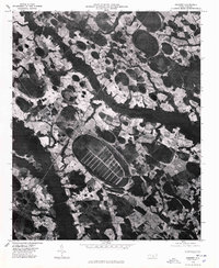
1976 Map of Rennert
USGS Topo · Published 1978About this map
Rennert and its surrounding agricultural landscape appear in sharp detail on this mid-1970s orthophotoquad. The imagery reveals the unique geological and land-use patterns of Robeson County, characterized by the dark, winding corridor of Big Marsh Swamp cutting through a mosaic of farm fields and woodland patches. A particularly striking feature is the Great Desert, a large, elliptical depression marked by a systematic grid of drainage or access tracks, reflecting the intensive land management common to this region of the coastal plain. Scattered farmsteads and rural roads connect to the central settlement of Rennert, while Mathis Pond sits toward the northeast corner of the sheet. This aerial perspective is a vital record of North Carolina's rural layout before more recent decades of development and changing agricultural practices.
Find a feature on this map
4 named features on this map. Tap any name to fly to it.
Don’t see what you’re looking for? This feature index may not catch every label — zoom into the map to look around manually.
Map Details
Editions of this 1976 Rennert Map
This is the sole edition of this map. No revisions or reprints were ever made.
Other maps of this area

1953 · Florence
USGS Topo · 1:250,000

1954 · Florence
USGS Topo · 1:250,000

1957 · Bladenboro
USGS Topo · 1:62,500

1959 · Saint Pauls
USGS Topo · 1:62,500

1972 · Northwest Lumberton
USGS Topo · 1:24,000

1972 · Rennert
USGS Topo · 1:24,000
1972 · Raeford
USGS Topo · 1:24,000

1972 · Pembroke
USGS Topo · 1:24,000
1972 · Parkton
USGS Topo · 1:24,000
1974 · Red Springs
USGS Topo · 1:24,000