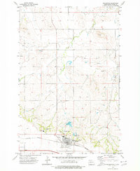
1973 Map of Richardton
USGS Topo · Published 1977About this map
Assumption Abbey and Sacred Heart Priory anchor the southern portion of this landscape, marking the cultural and religious heart of Richardton during the early 1970s. The town sits at a critical transportation junction where the Burlington Northern railroad runs parallel to the primary highway, serving the region's agricultural and industrial needs. To the north of the settled area, Abbey Lake and a series of Sewage Disposal Ponds demonstrate the managed water systems necessary for the community's growth.
Find a feature on this map
21 named features on this map. Tap any name to fly to it.
Don’t see what you’re looking for? This feature index may not catch every label — zoom into the map to look around manually.
Map Details
Editions of this 1973 Richardton Map
This is the sole edition of this map. No revisions or reprints were ever made.
Other maps of this area

1953 · Dickinson
USGS Topo · 1:250,000

1953 · Watford City
USGS Topo · 1:250,000

1957 · Dickinson
USGS Topo · 1:250,000

1957 · Watford City
USGS Topo · 1:250,000

1967 · Watford City
USGS Topo · 1:250,000

1973 · Bratburg Butte
USGS Topo · 1:24,000

1973 · Marshall SE
USGS Topo · 1:24,000

1973 · Taylor
USGS Topo · 1:24,000

1973 · Willow Creek West
USGS Topo · 1:24,000

1973 · Marshall SW
USGS Topo · 1:24,000