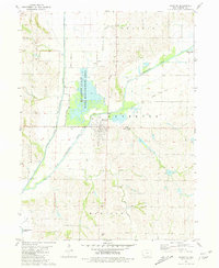
1981 Map of Riverton
USGS Topo · Published 1981About this map
Riverton occupies the center of this landscape at the confluence of the West Nishnabotna River and East Nishnabotna River. The topography is dominated by the extensive Riverton State Game Management Area, which preserves a complex network of wetlands and seasonal water bodies within the river basin. For local historians, the sheet documents the transition of the regional transportation network, specifically the presence of an Old Railroad Grade running east of the town. Outside the main settlement, rural land use is indicated by various small drainages like Mill Creek and Madison Creek, as well as established family-named landmarks such as Redd Cem and Utterback Cem. The map provides a clear picture of the hydrological management and agricultural layout in southern Fremont County during the early 1980s.
Find a feature on this map
21 named features on this map. Tap any name to fly to it.
Don’t see what you’re looking for? This feature index may not catch every label — zoom into the map to look around manually.
Map Details
Editions of this 1981 Riverton Map
This is the sole edition of this map. No revisions or reprints were ever made.
Other maps of this area

1939 · Farragut
USGS Topo · 1:62,500

1939 · Hamburg
USGS Topo · 1:62,500

1940 · Farragut
USGS Topo · 1:62,500

1941 · Hamburg
USGS Topo · 1:62,500

1955 · Nebraska City
USGS Topo · 1:250,000

1957 · Nebraska City
USGS Topo · 1:250,000

1957 · Randolph
USGS Topo · 1:24,000

1957 · Tabor SW
USGS Topo · 1:24,000

1958 · Nebraska City
USGS Topo · 1:250,000
1966 · Hamburg
USGS Topo · 1:24,000