
1904 Map of Rockland
USGS Topo · Published 1961About this map
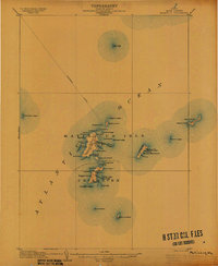
The coastal communities of Rockland, Camden, and Rockport define this 1904 survey, which reveals a landscape where maritime industry and emerging tourism intersect. The shoreline is a dense network of points and ledges, while the interior is marked by scattered settlements like Blackinton Corners and Simonton Corners. Local infrastructure is anchored by the Maine Central RR, with its Rockland Branch terminating at the harbor, and an Electric line connecting the larger towns.
Find a feature on this map
161 named features on this map. Tap any name to fly to it.
Don’t see what you’re looking for? This feature index may not catch every label — zoom into the map to look around manually.
Map Details
Editions of this 1904 Rockland Map
This is the sole edition of this map. No revisions or reprints were ever made.
Other maps of this area

1902 · Castine
USGS Topo · 1:62,500

1904 · Castine
USGS Topo · 1:62,500

1904 · Vinalhaven
USGS Topo · 1:62,500

1904 · Monhegan
USGS Topo · 1:62,500

1904 · Tenants Harbor
USGS Topo · 1:62,500

1905 · Penobscot Bay
USGS Topo · 1:125,000
1906 · Matinicus
USGS Topo · 1:62,500

1906 · Tennant Harbor
USGS Topo · 1:62,500

1906 · Monhegan
USGS Topo · 1:62,500

1906 · Rockland
USGS Topo · 1:62,500