
Loading...
Loading map...2024 Map of Rogers
USGS Topo · Published 2024About this map
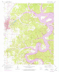
The city of Rogers serves as the urban anchor in this Northwest Arkansas landscape, where the expansion of Little Flock and suburban developments like Prairie Creek meet the winding eastern shoreline of Beaver Lake. The map documents a complex transition from city streets to the deeply dissected terrain of the White River valley. This area is noted for its historic springs, including Electric Springs, Diamond Spring, and Esculapia Spring, which once drew visitors to the region.
Find a feature on this map
79 named features on this map. Tap any name to fly to it.
Don’t see what you’re looking for? This feature index may not catch every label — zoom into the map to look around manually.
Map Details
Date Portrayed2024
Date Published2024
PublisherU.S. Geological Survey
Map TypeTopographic
Scale1:24000
Physical Dimensions24 x 29 inches
Editions of this 2024 Rogers Map
This is the sole edition of this map. No revisions or reprints were ever made.
Historical Maps of Monte Ne Through Time
Featured Locations
Source Details
SourceU.S. Geological Survey
CopyrightPublic Domain