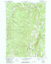
1984 Map of Roxbury
USGS Topo · Published 1991About this map
The Central Vermont rail line follows the narrow valley of the Dog River through the heart of the Green Mountains, connecting Roxbury and South Northfield. This area is characterized by high ridges like Shaw Mtn and Belcher Hill, where small settlements and camps were established along the steep drainages. The map records several small spiritual and educational centers, including the United Ch, St Helena Ch, and the Rabbit Hollow Sch. Local industry is reflected in the numerous gravel pits and a Quarry near the northern boundary, while the State Fish Hatchery near Roxbury Flat indicates a long-standing commitment to the region's natural resources. Genealogists will find the locations of the Orcutt Cem and First Settler Cem particularly valuable for tracing early families in this landscape of high peaks and winding brooks.
Find a feature on this map
58 named features on this map. Tap any name to fly to it.
Don’t see what you’re looking for? This feature index may not catch every label — zoom into the map to look around manually.
Map Details
Editions of this 1984 Roxbury Map
This is the sole edition of this map. No revisions or reprints were ever made.
Other maps of this area

1915 · Rochester
USGS Topo · 1:62,500

1917 · Rochester
USGS Topo · 1:62,500

1919 · Royalton
USGS Topo · 1:62,500

1919 · Lincoln Mountain
USGS Topo · 1:62,500

1920 · Lincoln Mountain
USGS Topo · 1:48,000

1921 · Lincoln Mountain
USGS Topo · 1:62,500

1922 · Barre
USGS Topo · 1:48,000

1924 · Barre
USGS Topo · 1:62,500

1924 · Randolph
USGS Topo · 1:48,000

1926 · Randolph
USGS Topo · 1:62,500