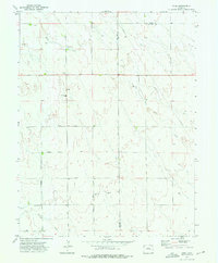
1973 Map of Rush
USGS Topo · Published 1976About this map
The small community of Rush serves as a focal point in this high plains landscape of eastern El Paso and Lincoln Counties. Surveyed in the early 1970s, the map reveals a sparsely populated ranching and farming region defined by seasonal watercourses like Steels Fork and Pond Creek. The layout of the land is strictly organized by a network of rural routes, including Whittemore Road, Sanborn Road, and Johnson Road, which connect isolated homesteads and operations. For genealogists and local historians, specific landmarks like the Crescent Cem and the District 60 Jr Sch provide essential anchor points for family research in this part of the Colorado plains. Several Gravel Pits are scattered across the terrain, indicating the localized resource extraction that supported the area's infrastructure.
Find a feature on this map
15 named features on this map. Tap any name to fly to it.
Don’t see what you’re looking for? This feature index may not catch every label — zoom into the map to look around manually.
Map Details
Editions of this 1973 Rush Map
This is the sole edition of this map. No revisions or reprints were ever made.
Other maps of this area

1889 · Sanborn
USGS Topo · 1:125,000

1891 · Sanborn
USGS Topo · 1:125,000

1893 · Sanborn
USGS Topo · 1:125,000

1893 · Big Springs
USGS Topo · 1:125,000

1954 · Lamar
USGS Topo · 1:250,000

1954 · Pueblo
USGS Topo · 1:250,000

1957 · Pueblo
USGS Topo · 1:250,000

1958 · Pueblo
USGS Topo · 1:250,000

1958 · Lamar
USGS Topo · 1:250,000

1962 · Pueblo
USGS Topo · 1:250,000