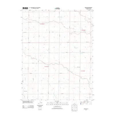
2013 Map of Rush NW
USGS Topo · Published 2013About this map
Steels Fork and its various tributaries define the drainage patterns of this high plains landscape in eastern El Paso County. The map reveals a highly structured grid of section lines and gravel roads, including Ramah Hwy, Judge Orr Rd, and Big Springs Rd, which facilitate transport across the rural terrain. While primarily agricultural and ranch land, the presence of private aviation facilities like Peakview Airport and Tranquila Airport indicates the modern utility of these large land holdings. Water management is central to the area's sustainability, shown through features such as Minkler Detention Reservoir Number 1 and Charles Golding Reservoir. The detailed hydrography of Horse Cr and the W Br Steels Fork Horse Cr provides a precise view of the seasonal watercourses that shape the local geography.
Find a feature on this map
40 named features on this map. Tap any name to fly to it.
Don’t see what you’re looking for? This feature index may not catch every label — zoom into the map to look around manually.
Map Details
Editions of this 2013 Rush NW Map
This is the sole edition of this map. No revisions or reprints were ever made.
Other maps of this area
1893 · Big Springs
USGS Topo · 1:125,000
1953 · Denver
USGS Topo · 1:250,000
1954 · Pueblo
USGS Topo · 1:250,000
1957 · Denver
USGS Topo · 1:250,000
1957 · Pueblo
USGS Topo · 1:250,000
1958 · Pueblo
USGS Topo · 1:250,000
1958 · Denver
USGS Topo · 1:250,000
1960 · Denver
USGS Topo · 1:250,000
1962 · Pueblo
USGS Topo · 1:250,000
1966 · Pueblo
USGS Topo · 1:250,000