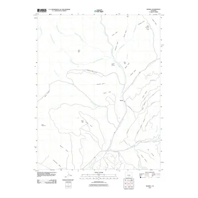
2010 Map of Russell
USGS Topo · Published 2010About this map
Sangre de Cristo Creek serves as the primary drainage through this mountainous corridor of Costilla County, carving a path through high-elevation terrain punctuated by mining history. The small settlement of Russell sits near the confluence of Placer Creek, marking a junction where the valley widens. Evidence of early twentieth-century extraction is scattered across the landscape, particularly in the northern reaches where several claims are concentrated. These include the Lone Star of the West Mine and the Monte Cristo Mine, alongside the Midnight Mine and Paul H Mine further east.
Find a feature on this map
55 named features on this map. Tap any name to fly to it.
Don’t see what you’re looking for? This feature index may not catch every label — zoom into the map to look around manually.
Map Details
Editions of this 2010 Russell Map
This is the sole edition of this map. No revisions or reprints were ever made.
Other maps of this area

1889 · Huerfano Park
USGS Topo · 1:125,000

1892 · Huerfano Park
USGS Topo · 1:125,000

1954 · Trinidad
USGS Topo · 1:250,000

1955 · Trinidad
USGS Topo · 1:250,000

1958 · Trinidad
USGS Topo · 1:250,000

1959 · Trinidad
USGS Topo · 1:250,000

1963 · Mc Carty Park
USGS Topo · 1:24,000

1963 · La Veta Pass
USGS Topo · 1:24,000

1967 · Mosca Pass
USGS Topo · 1:24,000
1967 · Blanca Peak
USGS Topo · 1:24,000