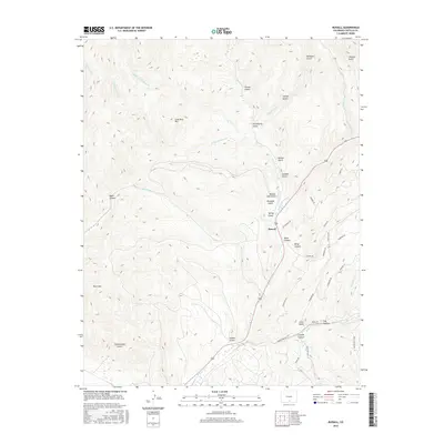
2016 Map of Russell
USGS Topo · Published 2016About this map
Russell sits at the heart of this Costilla County landscape, where the high-altitude terrain of the Sangre de Cristo Mountains is defined by a complex network of drainages and canyons. The settlement is positioned near the confluence of several vital water sources, including Sangre de Cristo Cr and Placer Cr. To the west, the topography rises toward Buck Mtn and Lone Rock Hill, while the eastern side of the quadrangle is marked by modern residential road names such as Lautenberg Dr and Forbes Park Rd. These newer residential developments contrast with the traditional landmarks of the area, like Spanish Gulch and Bronco Dan Gulch, illustrating the transition of these high-elevation valleys into more developed foothill communities. The drainage patterns of Wagon Cr and Malo Vega Cr further indicate the hydrological importance of this area in the San Luis Valley watershed.
Find a feature on this map
47 named features on this map. Tap any name to fly to it.
Don’t see what you’re looking for? This feature index may not catch every label — zoom into the map to look around manually.
Map Details
Editions of this 2016 Russell Map
This is the sole edition of this map. No revisions or reprints were ever made.
Other maps of this area

1889 · Huerfano Park
USGS Topo · 1:125,000

1892 · Huerfano Park
USGS Topo · 1:125,000

1954 · Trinidad
USGS Topo · 1:250,000

1955 · Trinidad
USGS Topo · 1:250,000

1958 · Trinidad
USGS Topo · 1:250,000

1959 · Trinidad
USGS Topo · 1:250,000

1963 · Mc Carty Park
USGS Topo · 1:24,000

1963 · La Veta Pass
USGS Topo · 1:24,000

1967 · Mosca Pass
USGS Topo · 1:24,000
1967 · Blanca Peak
USGS Topo · 1:24,000