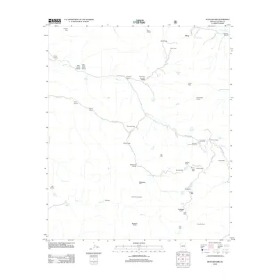
2012 Map of Rustler Park
USGS Topo · Published 2012About this map
Hilltop and the surrounding high-elevation terrain define this landscape in the Chiricahua Mountains during the early 21st century. The network of Forest Service roads, including Pinery Canyon Rd and Barfoot Park Rd, provides access to numerous recreational sites such as the Rustler Park Campground and Upper Pinery Canyon Campground. The geography is marked by a series of prominent peaks and saddles, such as Barfoot Peak and Bootlegger Saddle, which separate deep drainages like Pinery Canyon and Rattlesnake Canyon. This survey illustrates a wilderness utilized for both modern recreation and historic resource management, evidenced by the presence of Barfoot Lookout and Kasper Tunnel. Water sources are critical in this environment, with numerous named features such as Bear Wallow Spring, Onion Spring, and Hillside Spring supporting the local ecosystem and campers at the Methodist Camp.
Find a feature on this map
68 named features on this map. Tap any name to fly to it.
Don’t see what you’re looking for? This feature index may not catch every label — zoom into the map to look around manually.
Map Details
Editions of this 2012 Rustler Park Map
This is the sole edition of this map. No revisions or reprints were ever made.
Other maps of this area
1917 · San Simon
USGS Topo · 1:125,000
1917 · Chiricahua
USGS Topo · 1:125,000
1919 · Chiricahua
USGS Topo · 1:125,000
1926 · Cochise Head
USGS Topo · 1:62,500
1926 · Rodeo
USGS Topo · 1:62,500
1926 · Rucker
USGS Topo · 1:62,500
1928 · Chenoweth
USGS Topo · 1:62,500
1950 · Cochise Head
USGS Topo · 1:62,500
1950 · Vanar
USGS Topo · 1:62,500
1951 · Vanar
USGS Topo · 1:62,500