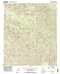
1998 Map of Rustler Park
USGS Topo · Published 2003About this map
Chiricahua National Monument and the surrounding wilderness of the Coronado National Forest dominate this landscape in the late 1990s. The map reveals a legacy of resource extraction concentrated in the north, where several shafts and tunnels are noted, including the Lead Lily Shaft and the Blacksmith Tunnel. Higher elevations are marked by seasonal and permanent waters such as Riggs Spring and Barfoot Spring, which supported high-country activities. The presence of the Rustler Park Lookout and a Forest Service Station at Rustler Park indicates the ongoing importance of fire monitoring and land management in this densely contoured region. Historic land use is further evidenced by isolated landmarks like the Headquarters Windmill, a lonely Grave near Pinery Creek, and the Fitch Corral, showing how ranching and mining persisted even in these high, protected canyons.
Find a feature on this map
92 named features on this map. Tap any name to fly to it.
Don’t see what you’re looking for? This feature index may not catch every label — zoom into the map to look around manually.
Map Details
Editions of this 1998 Rustler Park Map
This is the sole edition of this map. No revisions or reprints were ever made.
Other maps of this area

1917 · San Simon
USGS Topo · 1:125,000

1917 · Chiricahua
USGS Topo · 1:125,000

1919 · Chiricahua
USGS Topo · 1:125,000

1926 · Cochise Head
USGS Topo · 1:62,500

1926 · Rodeo
USGS Topo · 1:62,500

1926 · Rucker
USGS Topo · 1:62,500

1928 · Chenoweth
USGS Topo · 1:62,500

1950 · Cochise Head
USGS Topo · 1:62,500

1950 · Vanar
USGS Topo · 1:62,500

1951 · Vanar
USGS Topo · 1:62,500