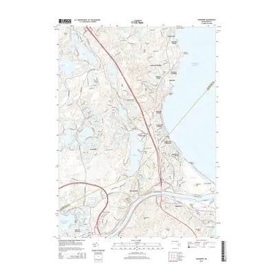
2015 Map of Sagamore
USGS Topo · Published 2015About this map
Sagamore and the maritime gateway of the Cape Cod Canal define this coastal landscape where the Intracoastal Waterway cuts through the glacial terrain. The map documents a corridor of high-density settlement along the Atlantic shore, from Vallersville and Bayside Beach in the north down to Sagamore Beach. A massive complex of freshwater ponds, including Great Herring Pond and Long Pond, sits just inland, showing the characteristic pitted topography of the region. Local heritage is marked by sites like the Cedarville Cem and Bay View Cem, while major infrastructure like the Sagamore Bridge and Bourne Bridge provides critical links across the canal. The varied elevations of Eagle Hill, Signal Hill, and Faunces Mtn overlook a mix of developed coastal heights like Nameloc Heights and the dense network of roads connecting Bournedale to the bay.
Find a feature on this map
91 named features on this map. Tap any name to fly to it.
Don’t see what you’re looking for? This feature index may not catch every label — zoom into the map to look around manually.
Map Details
Editions of this 2015 Sagamore Map
This is the sole edition of this map. No revisions or reprints were ever made.
Other maps of this area

1886 · Falmouth
USGS Topo · 1:62,500

1886 · Plymouth
USGS Topo · 1:62,500

1888 · Barnstable
USGS Topo · 1:62,500

1888 · Falmouth
USGS Topo · 1:62,500

1889 · Plymouth
USGS Topo · 1:62,500

1893 · Barnstable
USGS Topo · 1:62,500

1893 · Falmouth
USGS Topo · 1:62,500

1894 · Plymouth
USGS Topo · 1:62,500

1915 · Falmouth
USGS Topo · 1:62,500

1920 · Falmouth
USGS Topo · 1:62,500