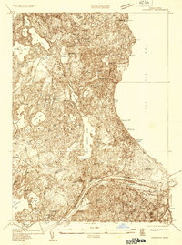
1933 Map of Sagamore
USGS Topo · Published 1933About this map
The Cape Cod Canal serves as the dominant industrial landmark of this early 1930s survey, cutting across the southern portion of the map near the town of Sagamore. The landscape is defined by an intricate network of kettle ponds and coastal bogs, such as Great Herring Pond and Ellis Bog, reflecting the region's post-glacial topography. Small residential clusters like Long Pond Village and Halfway Pond Village are shown connected by early road networks, while the coastline of Cape Cod Bay features prominent elevations like Peaked Cliff and the development at Nameloc Heights.
Find a feature on this map
63 named features on this map. Tap any name to fly to it.
Don’t see what you’re looking for? This feature index may not catch every label — zoom into the map to look around manually.
Map Details
Editions of this 1933 Sagamore Map
This is the sole edition of this map. No revisions or reprints were ever made.
Other maps of this area

1886 · Falmouth
USGS Topo · 1:62,500

1886 · Plymouth
USGS Topo · 1:62,500

1888 · Barnstable
USGS Topo · 1:62,500

1888 · Falmouth
USGS Topo · 1:62,500

1889 · Plymouth
USGS Topo · 1:62,500

1893 · Barnstable
USGS Topo · 1:62,500

1893 · Falmouth
USGS Topo · 1:62,500

1894 · Plymouth
USGS Topo · 1:62,500

1915 · Falmouth
USGS Topo · 1:62,500

1920 · Falmouth
USGS Topo · 1:62,500