1947 Map of Salinas NE
USGS Topo · Published 1947About this map
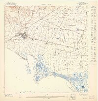
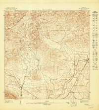
Agricultural enterprise and coastal logistics define this 1940s landscape along the southern coast of Puerto Rico. The town of Salinas serves as a central hub, connected to the sugar industry via the Linea Ponce and Guayama railroad and the Central Caribe mill. The surrounding terrain is heavily partitioned into various estates and settlements, including Hacienda Margarita, Hacienda Carmen, and Colonia Fortuna, illustrating the era's land use patterns. Irrigation infrastructure is prominent, with the Canal de Patillas and Canal de Guamani cutting across the coastal plain to support the local plantations.
Find a feature on this map
23 named features on this map. Tap any name to fly to it.
Don’t see what you’re looking for? This feature index may not catch every label — zoom into the map to look around manually.
Map Details
Editions of this 1947 Salinas NE Map
This is the sole edition of this map. No revisions or reprints were ever made.
Historical Maps of Villa Natalia Through Time
5 maps found
Featured Locations
- Corales del Mar, Salinas
- Villasol, Salinas
- Salinas, Salinas
- Sector Providencia, Salinas
- Urb. Brisas del Everlymar, Salinas