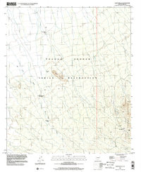
1996 Map of Sand Wells
USGS Topo · Published 2002About this map
The Tohono O'odham Indian Reservation landscape is defined by its arid terrain and the critical infrastructure developed to manage water in the Sonoran desert. Centered around Black Mountain, the map reveals a network of water management features, including Standing Bar Tank, Pad Wo'o Tank, and the Black Mtn Well. These sites, along with the Corral Water Tank, reflect the essential adaptations required for life and livestock in Pima County. The eastern portion of the sheet is dominated by the steep slopes of the North Comobabi Mountains, where several unnamed Prospects suggest historical interest in mineral exploration.
Find a feature on this map
13 named features on this map. Tap any name to fly to it.
Don’t see what you’re looking for? This feature index may not catch every label — zoom into the map to look around manually.
Map Details
Editions of this 1996 Sand Wells Map
This is the sole edition of this map. No revisions or reprints were ever made.
Other maps of this area

1934 · Silver Bell
USGS Topo · 1:125,000

1937 · Comobabi
USGS Topo · 1:48,000

1942 · Comobabi
USGS Topo · 1:62,500

1953 · Ajo
USGS Topo · 1:250,000

1956 · Tucson
USGS Topo · 1:250,000

1957 · Ajo
USGS Topo · 1:250,000

1958 · Ajo
USGS Topo · 1:250,000

1958 · Tucson
USGS Topo · 1:250,000

1959 · Tucson
USGS Topo · 1:250,000

1962 · Ajo
USGS Topo · 1:250,000