
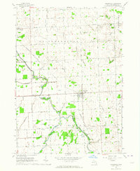
1963 Map of Sandusky
USGS Topo · Published 1964About this map
Sandusky serves as the regional hub at the convergence of several major township lines during the early 1960s. The landscape is characterized by a sophisticated drainage network, with dozens of named features like Brice Drain, Nicol Drain, and Kinney Drain supporting the local agricultural economy. The Chesapeake and Ohio Railroad cuts across the center of the sheet, linking the town's industrial facilities, such as the local Substation and Sewage Disposal plant, to the broader Michigan rail network.
Find a feature on this map
65 named features on this map. Tap any name to fly to it.
Don’t see what you’re looking for? This feature index may not catch every label — zoom into the map to look around manually.
Map Details
Editions of this 1963 Sandusky Map
This is the sole edition of this map. No revisions or reprints were ever made.
Other maps of this area

1954 · Flint
USGS Topo · 1:250,000

1958 · Flint
USGS Topo · 1:250,000

1963 · Snover
USGS Topo · 1:24,000

1963 · Peck
USGS Topo · 1:24,000

1963 · Juhl
USGS Topo · 1:24,000

1963 · Palms
USGS Topo · 1:24,000

1963 · Applegate
USGS Topo · 1:24,000

1963 · Deckerville
USGS Topo · 1:24,000

1963 · Argyle
USGS Topo · 1:24,000
1963 · Carsonville
USGS Topo · 1:24,000