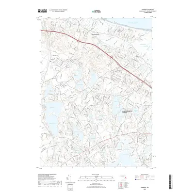
2018 Map of Sandwich
USGS Topo · Published 2018About this map
East Sandwich and the northern reaches of Barnstable Town define this coastal landscape, where the tidal influences of the Atlantic Ocean meet a dense network of inland kettle ponds and marshes. The map documents the intricate hydrology of the region, from the winding Scorton Creek and its associated Great Marshes to the large freshwater bodies of Peters Pond, Wakeby Pond, and Mashpee Pond. For genealogists and local historians, the sheet is particularly valuable for its documentation of numerous burial grounds, including Cedarville Cem, Tobey Cem, and Mosswood Cem. This 2018 survey also highlights modern infrastructure such as the Cape Cod Airport and the complex residential road networks that have grown around the glacial topography. Small water features like Doughnut Pond and Hoxie Pond punctuate the terrain, illustrating the glacial legacy of the upper Cape.
Find a feature on this map
323 named features on this map. Tap any name to fly to it.
Don’t see what you’re looking for? This feature index may not catch every label — zoom into the map to look around manually.
Map Details
Editions of this 2018 Sandwich Map
This is the sole edition of this map. No revisions or reprints were ever made.
Other maps of this area

1886 · Falmouth
USGS Topo · 1:62,500

1886 · Plymouth
USGS Topo · 1:62,500

1888 · Barnstable
USGS Topo · 1:62,500

1888 · Falmouth
USGS Topo · 1:62,500

1889 · Plymouth
USGS Topo · 1:62,500

1893 · Barnstable
USGS Topo · 1:62,500

1893 · Falmouth
USGS Topo · 1:62,500

1894 · Plymouth
USGS Topo · 1:62,500

1915 · Falmouth
USGS Topo · 1:62,500

1920 · Falmouth
USGS Topo · 1:62,500