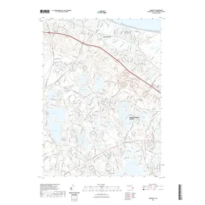
2021 Map of Sandwich
USGS Topo · Published 2021About this map
East Sandwich and the northern reaches of Barnstable Town are defined by a complex glacial landscape of kettle ponds and coastal marshes. Large water bodies such as Mashpee Pond, Peters Pond, and Lawrence Pond dominate the interior, while Scorton Creek Marshes and the Sandwich Harbor Marshes protect the northern shoreline along Sandy Neck. This 2021 survey reveals a modern residential network woven through a series of trails and paths, including the Trail of Tears North Trl and North Ridge Trl, reflecting the area's transition toward conservation and recreation. Numerous family-named burial sites, such as Tobey Cem, Percival Cem, and Wakeby Cem, provide significant touchstones for local genealogists. The presence of the Cape Cod Airport near Mystic Lake further highlights the unique infrastructure that services this portion of the Cape.
Find a feature on this map
80 named features on this map. Tap any name to fly to it.
Don’t see what you’re looking for? This feature index may not catch every label — zoom into the map to look around manually.
Map Details
Editions of this 2021 Sandwich Map
This is the sole edition of this map. No revisions or reprints were ever made.
Other maps of this area

1886 · Falmouth
USGS Topo · 1:62,500

1886 · Plymouth
USGS Topo · 1:62,500

1888 · Barnstable
USGS Topo · 1:62,500

1888 · Falmouth
USGS Topo · 1:62,500

1889 · Plymouth
USGS Topo · 1:62,500

1893 · Barnstable
USGS Topo · 1:62,500

1893 · Falmouth
USGS Topo · 1:62,500

1894 · Plymouth
USGS Topo · 1:62,500

1915 · Falmouth
USGS Topo · 1:62,500

1920 · Falmouth
USGS Topo · 1:62,500