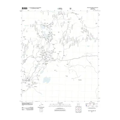
2011 Map of Santa Rita Mine
USGS Topo · Published 2011About this map
Fierro and Hanover sit at the heart of this intensive mining landscape, where the terrain is dense with the infrastructure of silver, copper, and iron extraction. The map reveals an intricate network of shafts, tunnels, and pits such as the Barringer Incline Mine, Continental Mine, and the Union Hill Mine. These workings dominate the valleys and hillsides, linked by a complex web of industrial roads including Fierro Rd and W and L Mine Rd. The human footprint of the mining era is visible in the clusters of settlements like Turnerville and Wimsattville, each served by its own post office or local landmark. Beyond the industrial core, the map tracks the quieter edges of the district, from the Georgetown Cemetery near the eastern boundary to the Kennecott Dam Number Eight, illustrating how the massive scale of the Santa Rita mining operations redefined the surrounding landscape.
Find a feature on this map
151 named features on this map. Tap any name to fly to it.
Don’t see what you’re looking for? This feature index may not catch every label — zoom into the map to look around manually.
Map Details
Editions of this 2011 Santa Rita Mine Map
This is the sole edition of this map. No revisions or reprints were ever made.
Other maps of this area

1909 · Silver City
USGS Topo · 1:125,000

1937 · Santa Rita
USGS Topo · 1:24,000

1947 · Allie Canyon
USGS Topo · 1:24,000

1947 · Twin Sisters
USGS Topo · 1:24,000

1947 · Fort Bayard
USGS Topo · 1:24,000

1948 · Twin Sisters
USGS Topo · 1:24,000

1948 · Santa Rita
USGS Topo · 1:24,000

1948 · Allie Canyon
USGS Topo · 1:24,000

1948 · Hurley East
USGS Topo · 1:24,000

1949 · Fort Bayard
USGS Topo · 1:24,000