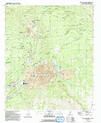
1992 Map of Santa Rita Mine
USGS Topo · Published 1992About this map
The massive Santa Rita Mine dominates the center of this landscape, its expansive open-pit operations and tailing piles illustrating the scale of copper mining in Grant County during the late 20th century. This industrial core is surrounded by several company towns and historic settlements, including Fierro, Hanover, and Wimsattville. The map captures the infrastructure of the mining district, noting specific landmarks like the Continental Mine, the Kearney Mine, and the Princess Shaft. To the south, the community of Bayard marks the edge of the mining activity near the Atchison Topeka and Santa Fe RR line.
Find a feature on this map
51 named features on this map. Tap any name to fly to it.
Don’t see what you’re looking for? This feature index may not catch every label — zoom into the map to look around manually.
Map Details
Editions of this 1992 Santa Rita Mine Map
This is the sole edition of this map. No revisions or reprints were ever made.
Other maps of this area

1909 · Silver City
USGS Topo · 1:125,000

1937 · Santa Rita
USGS Topo · 1:24,000

1947 · Allie Canyon
USGS Topo · 1:24,000

1947 · Twin Sisters
USGS Topo · 1:24,000

1947 · Fort Bayard
USGS Topo · 1:24,000

1948 · Twin Sisters
USGS Topo · 1:24,000

1948 · Santa Rita
USGS Topo · 1:24,000

1948 · Allie Canyon
USGS Topo · 1:24,000

1948 · Hurley East
USGS Topo · 1:24,000

1949 · Fort Bayard
USGS Topo · 1:24,000