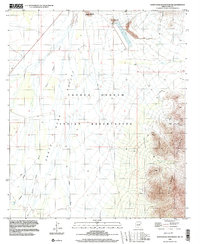
1996 Map of Santa Rosa Mountains NW
USGS Topo · Published 2003About this map
The Tohono O'odham Indian Reservation dominates this desert landscape, where the wide Santa Rosa Valley meets the high elevations of the Santa Rosa Mountains. Evidence of small-scale mineral extraction is scattered throughout the eastern peaks, including a Miner Shaft and several locations marked Prospect. This mid-1990s data reflects a geography defined by intermittent water flow, with drainage systems like the Santa Rosa Wash, Sil Nakya Wash, and Anegam Wash carving paths through the arid terrain. Notable landmarks such as Owls Nest Mountain and Komelik Mountain rise above the valley floor. In the northern reaches, industrial features like a Riser and Tailings suggest more intensive land use near the reservation boundary, contrasting with the undeveloped stretches of 4WD tracks and foot trails used to navigate this corner of Pima County.
Find a feature on this map
18 named features on this map. Tap any name to fly to it.
Don’t see what you’re looking for? This feature index may not catch every label — zoom into the map to look around manually.
Map Details
Editions of this 1996 Santa Rosa Mountains NW Map
This is the sole edition of this map. No revisions or reprints were ever made.
Other maps of this area

1934 · Silver Bell
USGS Topo · 1:125,000

1941 · Vekol Mountains
USGS Topo · 1:62,500

1942 · Silver Reef Mountains
USGS Topo · 1:62,500

1942 · Vekol Mountains
USGS Topo · 1:62,500

1953 · Ajo
USGS Topo · 1:250,000

1956 · Tucson
USGS Topo · 1:250,000

1957 · Ajo
USGS Topo · 1:250,000

1958 · Ajo
USGS Topo · 1:250,000

1958 · Tucson
USGS Topo · 1:250,000

1959 · Tucson
USGS Topo · 1:250,000