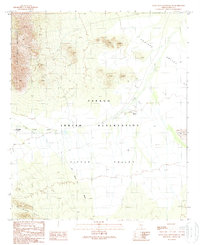
1989 Map of Santa Rosa Mountains SE
USGS Topo · Published 1989About this map
The Papago Indian Reservation defines the character of this desert landscape, where seasonal water drainage systems dictate the placement of human activity. Settlement sites like Hoi Oidak (Site) and Pipyak (Site) are documented alongside the Sil Nakya Wash, which flows south through the Pipyak Valley between the Sil Nakya Hills and the Santa Rosa Mountains. The presence of several Check Dams near the Pipyak site illustrates historical water management efforts in this arid environment. Evidence of mineral exploration appears in the western ridges, with multiple labels for a Prospect dotting the slopes, while the eastern portion of the sheet opens into the broad expanse of the Aguirre Valley near the Vaca Hills.
Find a feature on this map
12 named features on this map. Tap any name to fly to it.
Don’t see what you’re looking for? This feature index may not catch every label — zoom into the map to look around manually.
Map Details
Editions of this 1989 Santa Rosa Mountains SE Map
This is the sole edition of this map. No revisions or reprints were ever made.
Other maps of this area

1934 · Silver Bell
USGS Topo · 1:125,000

1937 · Comobabi
USGS Topo · 1:48,000

1938 · San Vicente
USGS Topo · 1:62,500

1941 · San Vicente
USGS Topo · 1:62,500

1942 · San Vicente
USGS Topo · 1:62,500

1942 · Comobabi
USGS Topo · 1:62,500

1948 · San Vicente
USGS Topo · 1:62,500

1956 · Tucson
USGS Topo · 1:250,000

1958 · Tucson
USGS Topo · 1:250,000

1959 · Tucson
USGS Topo · 1:250,000