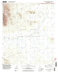
1996 Map of Santa Rosa Mountains SE
USGS Topo · Published 2003About this map
The Tohono O'odham Indian Reservation dominates this landscape in Pima County, where the desert floor meets the rising terrain of the Santa Rosa Mountains. The map documents the sites of Hoi Oidak and Pipyak, marking specific human footprints in a region defined by seasonal water flow and arid basins. These valleys, including the Aguirre Valley and Pipyak Valley, are connected by a network of 4WD tracks that follow the natural contours of the land rather than a formal grid. The drainage of Sil Nakya Wash runs between the Sil Nakya Hills and the Vaca Hills, illustrating how the hydrology of the Sonoran Desert dictates movement and settlement. Small-scale mining activity is evidenced by a prospect in the northwest, while the northern edge touches the Ironwood Forest National Monument, showing the intersection of tribal lands and federal conservation areas in the late 20th century.
Find a feature on this map
12 named features on this map. Tap any name to fly to it.
Don’t see what you’re looking for? This feature index may not catch every label — zoom into the map to look around manually.
Map Details
Editions of this 1996 Santa Rosa Mountains SE Map
This is the sole edition of this map. No revisions or reprints were ever made.
Other maps of this area

1934 · Silver Bell
USGS Topo · 1:125,000

1937 · Comobabi
USGS Topo · 1:48,000

1938 · San Vicente
USGS Topo · 1:62,500

1941 · San Vicente
USGS Topo · 1:62,500

1942 · San Vicente
USGS Topo · 1:62,500

1942 · Comobabi
USGS Topo · 1:62,500

1948 · San Vicente
USGS Topo · 1:62,500

1956 · Tucson
USGS Topo · 1:250,000

1958 · Tucson
USGS Topo · 1:250,000

1959 · Tucson
USGS Topo · 1:250,000