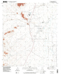
1996 Map of Santa Rosa
USGS Topo · Published 2001About this map
The Tohono O'odham Indian Reservation landscape is defined by the broad drainage patterns of the Santa Rosa Wash and Anegam Wash as they move through the Window Valley. This mid-1990s record of the region shows established community centers such as Anegam and Santa Rosa (Gu Achi), which serve as focal points for the surrounding rural area. Notable landmarks of cultural and civic importance are well-documented, including the Childrens Shrine and the Santa Rosa School.
Find a feature on this map
26 named features on this map. Tap any name to fly to it.
Don’t see what you’re looking for? This feature index may not catch every label — zoom into the map to look around manually.
Map Details
Editions of this 1996 Santa Rosa Map
This is the sole edition of this map. No revisions or reprints were ever made.
Other maps of this area

1934 · Silver Bell
USGS Topo · 1:125,000

1937 · Comobabi
USGS Topo · 1:48,000

1942 · Comobabi
USGS Topo · 1:62,500

1953 · Ajo
USGS Topo · 1:250,000

1956 · Tucson
USGS Topo · 1:250,000

1957 · Ajo
USGS Topo · 1:250,000

1958 · Ajo
USGS Topo · 1:250,000

1958 · Tucson
USGS Topo · 1:250,000

1959 · Tucson
USGS Topo · 1:250,000

1962 · Ajo
USGS Topo · 1:250,000
Featured Places
- Anegam, Sif Oidak District
- Ak Chin, Gu Achi District
- San Luis, Gu Achi District
- Sif Oidak District, AZ
- Santa Rosa, Gu Achi District