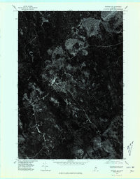
1975 Map of Saponac SW
USGS Topo · Published 1980About this map
Greenfield appears as a sparse network of roads and clearings in this 1975 aerial orthophotograph, capturing the rural character of this Penobscot County landscape. The imagery reveals the intricate textures of the Maine forest, punctuated by small agricultural openings and isolated residential structures that reflect the region's long-standing reliance on timber and small-scale farming. Unlike a traditional topographic map, this survey provides a direct visual record of land use, showing the varied density of the tree canopy and the sharp lines of cut-overs. The primary corridor through Greenfield serves as the focal point for settlement, where the relationship between the cleared land and the surrounding wilderness is most evident. This visual data offers researchers a precise view of the terrain before later decades of regrowth or development altered the visible footprint of the community.
Find a feature on this map
1 named feature on this map. Tap any name to fly to it.
Don’t see what you’re looking for? This feature index may not catch every label — zoom into the map to look around manually.
Map Details
Editions of this 1975 Saponac SW Map
This is the sole edition of this map. No revisions or reprints were ever made.
Other maps of this area

1902 · Orono
USGS Topo · 1:62,500

1917 · Passadumkeag
USGS Topo · 1:62,500

1929 · Great Pond
USGS Topo · 1:48,000

1931 · Saponac
USGS Topo · 1:48,000

1932 · Great Pond
USGS Topo · 1:62,500

1934 · Saponac
USGS Topo · 1:62,500

1944 · Orono
USGS Topo · 1:62,500

1946 · Orono
USGS Topo · 1:62,500

1948 · Bangor
USGS Topo · 1:250,000

1954 · Millinocket
USGS Topo · 1:250,000
Featured Places
- Summit Township, ME
- T39 MD BPP, ME
- Grand Falls Township, ME
- Greenfield Township, ME
- Crocker Turn, Greenfield Township