1988 Map of Schurz
USGS Topo · Published 1988About this map
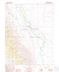
The town of Schurz serves as the focal point of this 1980s-era topographical study, situated where the Southern Pacific railroad meets the winding course of the Walker River. Located within the Walker River Indian Reservation, the landscape is defined by the contrast between the sharp rising peaks of the Wassuk Range to the west and the intricate irrigation network to the east. This system, including Canal No 1, Canal No 2, and various laterals like Lateral 1-A, illustrates the managed water resources vital to this desert valley. The map reveals localized infrastructure such as the Schurz Airport, an Athletic Field, and a small Cem north of the main settlement. Evidence of local industry and utility is visible through a Gravel Pit, scattered prospect markings, and a long Telephone Line tracing the valley floor.
Find a feature on this map
19 named features on this map. Tap any name to fly to it.
Don’t see what you’re looking for? This feature index may not catch every label — zoom into the map to look around manually.
Map Details
Editions of this 1988 Schurz Map
This is the sole edition of this map. No revisions or reprints were ever made.
Other maps of this area

1908 · Carson Sink
USGS Topo · 1:250,000

1909 · Hawthorne
USGS Topo · 1:250,000

1910 · Carson Sink
USGS Topo · 1:250,000

1911 · Hawthorne
USGS Topo · 1:250,000

1915 · Hawthorne
USGS Topo · 1:250,000

1948 · Walker Lake
USGS Topo · 1:250,000
1951 · Allen Springs
USGS Topo · 1:62,500
1951 · Weber Reservoir
USGS Topo · 1:62,500

1957 · Walker Lake
USGS Topo · 1:250,000

1957 · Reno
USGS Topo · 1:250,000