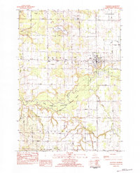
1983 Map of Scottville
USGS Topo · Published 1983About this map
Scottville serves as the primary hub in this West Michigan landscape, situated at the crossroads of established rural townships and the Chesapeake and Ohio railroad corridor. The area is defined by its deep agricultural and community roots, evidenced by the high density of family and town burial grounds such as North Amber Cem, Rickey Cem, and Brookside Cems. To the south, the terrain transforms as the Pere Marquette River and the Pere Marquette National Scenic River corridor cut through the topography, creating a distinct buffer between the northern farmlands of Amber and the southern reaches of Riverton. Local life at the time centered on small junctions like Stiles Corners and the Oil Field located just west of the main town site. Several country churches, including Reformed Ch and St Paul Ch, anchor the surrounding townships, marking the social centers of this 1980s rural environment.
Find a feature on this map
42 named features on this map. Tap any name to fly to it.
Don’t see what you’re looking for? This feature index may not catch every label — zoom into the map to look around manually.
Map Details
Editions of this 1983 Scottville Map
This is the sole edition of this map. No revisions or reprints were ever made.
Other maps of this area

1931 · Custer NW
USGS Topo · 1:31,680

1931 · Custer SW
USGS Topo · 1:31,680

1931 · Manistee SE
USGS Topo · 1:31,680

1931 · Freesoil SW
USGS Topo · 1:31,680

1931 · Manistee SW
USGS Topo · 1:31,680

1932 · Ludington NE
USGS Topo · 1:31,680

1932 · Ludington SW
USGS Topo · 1:31,680

1932 · Ludington SE
USGS Topo · 1:31,680

1932 · Ludington
USGS Topo · 1:31,680

1954 · Milwaukee
USGS Topo · 1:250,000