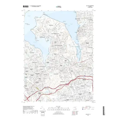
2019 Map of Sea Cliff
USGS Topo · Published 2019About this map
Manhasset Neck dominates the landscape of this North Shore region, carved by the waters of Manhasset Bay and Hempstead Harbor. The map highlights the intensive suburban development across a collection of historic villages including Port Washington, Plandome, and Great Neck. Genealogists will find a high concentration of burial grounds, such as Nassau Knolls Cem, Roslyn Cem, and Saint Pauls Cem, reflecting the deep roots of these communities. The southern portion of the sheet shows the major transportation corridors of the Long Island Expressway and Northern State Parkway as they pass through Lake Success and North Hills. This era of the map documents a fully matured residential landscape, where specialized landmarks like the Clark Botanic Garden and Whitney Lake sit amidst a complex network of coastal points and coves including Sands Point and Mosquito Cove.
Find a feature on this map
103 named features on this map. Tap any name to fly to it.
Don’t see what you’re looking for? This feature index may not catch every label — zoom into the map to look around manually.
Map Details
Editions of this 2019 Sea Cliff Map
This is the sole edition of this map. No revisions or reprints were ever made.
Other maps of this area

1889 · Brooklyn
USGS Topo · 1:62,500

1891 · Brooklyn
USGS Topo · 1:62,500

1891 · Harlem
USGS Topo · 1:62,500

1897 · Harlem
USGS Topo · 1:62,500

1897 · Brooklyn
USGS Topo · 1:62,500

1897 · Hempstead
USGS Topo · 1:62,500

1897 · Oyster Bay
USGS Topo · 1:62,500

1898 · Harlem
USGS Topo · 1:62,500

1898 · Hempstead
USGS Topo · 1:62,500

1898 · Brooklyn
USGS Topo · 1:62,500