
Loading...
Loading map...2023 Map of Sea Cliff
USGS Topo · Published 2023About this map
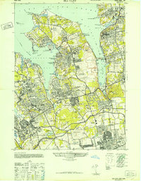
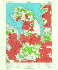
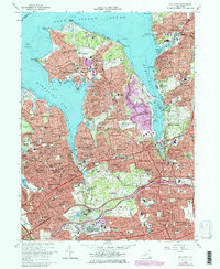
Manhasset Neck dominates the coastline of this Nassau County study, where the waters of Long Island Sound meet Hempstead Harbor and Manhasset Bay. The residential landscape is defined by its numerous incorporated villages and historic estates, reflecting a century of suburban refinement. Genealogists will find a high concentration of burial grounds including the Roslyn Cem and the older Monfort Cem near Port Washington.
Find a feature on this map
114 named features on this map. Tap any name to fly to it.
Don’t see what you’re looking for? This feature index may not catch every label — zoom into the map to look around manually.
Map Details
Date Portrayed2023
Date Published2023
PublisherU.S. Geological Survey
Map TypeTopographic
Scale1:24000
Physical Dimensions24 x 29 inches
Editions of this 2023 Sea Cliff Map
This is the sole edition of this map. No revisions or reprints were ever made.
Historical Maps of Kensington Through Time
4 maps found
Featured Locations
Source Details
SourceU.S. Geological Survey
CopyrightPublic Domain