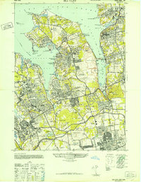
1947 Map of Sea Cliff
USGS Topo · Published 1947About this map
The estates of the North Shore dominate this mid-century landscape, reflecting the era's concentrated wealth along the coast of Long Island Sound. Grand properties such as the W R Hearst Estate, Guggenheim Estate, and Vanderbilt Estate occupy massive tracts of land, often complete with private amenities like the Whitney Polo Field. The maritime character of the region is anchored by the Sands Point Lh (New) and its predecessor, the Sands Point Lh (Old), while aviation history is marked by the New York Seaplane Airport on Manhasset Bay.
Find a feature on this map
145 named features on this map. Tap any name to fly to it.
Don’t see what you’re looking for? This feature index may not catch every label — zoom into the map to look around manually.
Map Details
Editions of this 1947 Sea Cliff Map
This is the sole edition of this map. No revisions or reprints were ever made.
Other maps of this area

1889 · Brooklyn
USGS Topo · 1:62,500

1891 · Brooklyn
USGS Topo · 1:62,500

1891 · Harlem
USGS Topo · 1:62,500

1897 · Harlem
USGS Topo · 1:62,500

1897 · Brooklyn
USGS Topo · 1:62,500

1897 · Hempstead
USGS Topo · 1:62,500

1897 · Oyster Bay
USGS Topo · 1:62,500

1898 · Harlem
USGS Topo · 1:62,500

1898 · Hempstead
USGS Topo · 1:62,500

1898 · Brooklyn
USGS Topo · 1:62,500