1919 Map of Sea Isle
USGS Topo · Published 1921About this map
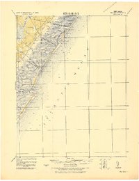
The coastal marshlands and barrier islands of Cape May are detailed here following field work conducted by the Corps of Engineers and the Geological Survey of New Jersey. The map highlights a complex network of waterways, including Ludlam Bay, Townsend Sound, and the Main Channel, which define the geography of the Jersey Shore before modern coastal development. Early transportation infrastructure is central to the landscape, with the Penna. R.R. and the Phila. & Reading R.R. providing essential links between inland communities like Ocean View and the growing seaside resorts of Sea Isle City and Avalon. Life-Saving Stations, such as L.S.S. Sea Isle City and L.S.S. Tatham, are positioned along the beaches of Whale Beach and Seven Mile Beach, marking the critical maritime safety infrastructure of the era.
Find a feature on this map
63 named features on this map. Tap any name to fly to it.
Don’t see what you’re looking for? This feature index may not catch every label — zoom into the map to look around manually.
Map Details
Editions of this 1919 Sea Isle Map
This is the sole edition of this map. No revisions or reprints were ever made.
Other maps of this area

1884 · Sea Isle
USGS Topo · 1:62,500

1887 · Atlantic City
USGS Topo · 1:62,500

1888 · Cape May
USGS Topo · 1:62,500

1888 · Dennisville
USGS Topo · 1:62,500

1888 · Sea Isle
USGS Topo · 1:62,500

1890 · Great Egg Harbor
USGS Topo · 1:62,500

1890 · Tuckahoe
USGS Topo · 1:62,500

1893 · Cape May
USGS Topo · 1:62,500

1893 · Great Egg Harbor
USGS Topo · 1:62,500

1893 · Tuckahoe
USGS Topo · 1:62,500