
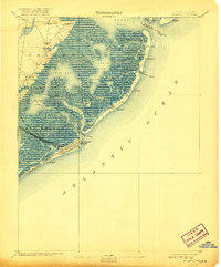
1887 Map of Atlantic City
USGS Topo · Published 1887About this map
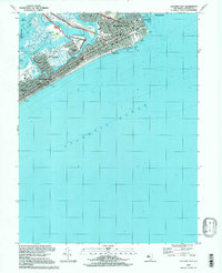
Atlantic City stands as a dense grid of development on the southern end of the barrier islands, already a major destination reached by an extensive network of iron rails in the late 19th century. Four distinct lines, including the Camden and Atlantic Railroad and the Philadelphia & Atlantic City Railroad, cross the wetlands of the mainland to connect the city to the interior. The Absecon Light and several Life Saving Stations along the coast highlight the critical maritime hazards of this era, marking the narrow inlets like Brigantine Inlet and New Inlet.
Find a feature on this map
58 named features on this map. Tap any name to fly to it.
Don’t see what you’re looking for? This feature index may not catch every label — zoom into the map to look around manually.
Map Details
Editions of this 1887 Atlantic City Map
This is the sole edition of this map. No revisions or reprints were ever made.
Historical Maps of Egg Harbor Township Through Time
13 maps found
1887 Atlantic City
Atlantic County, NJ
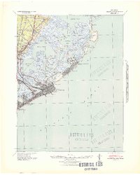
1894 Atlantic City
Atlantic County, NJ

1940 Atlantic City
Atlantic County, NJ
1941 Atlantic City
Atlantic County, NJ
1952 Atlantic City
Atlantic County, NJ

1984 Atlantic City
Atlantic County, NJ
1989 Atlantic City
Atlantic County, NJ
1994 Atlantic City
Atlantic County, NJ
2011 Atlantic City
Atlantic County, NJ
2014 Atlantic City
Atlantic County, NJ
2016 Atlantic City
Atlantic County, NJ
2019 Atlantic City
Atlantic County, NJ
2023 Atlantic City
Atlantic County, NJ
Featured Locations
- Galloway Township, NJ
- Atlantic City, NJ
- Pleasantville, NJ
- Egg Harbor Township, NJ
- Little Egg Harbor Township, NJ