
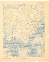
1888 Map of Little Egg Harbor
USGS Topo · Published 1888About this map
The Tuckerton Railroad cuts a diagonal path through this coastal landscape, connecting the inland cedar swamps and pine barrens to the thriving maritime communities of the late nineteenth century. Small hamlets like Manahawken, Staffordville, and Parkertown line the transition between the upland woods and the salt marshes. The map reveals an economy tied to both land and sea, featuring Stafford Forge and its associated Stafford Forge Pond alongside numerous coastal settlements.
Find a feature on this map
83 named features on this map. Tap any name to fly to it.
Don’t see what you’re looking for? This feature index may not catch every label — zoom into the map to look around manually.
Map Details
Editions of this 1888 Little Egg Harbor Map
2 editions found
Other maps of this area

1884 · Whitings
USGS Topo · 1:62,500

1887 · Atlantic City
USGS Topo · 1:62,500

1888 · Pemberton
USGS Topo · 1:62,500

1888 · Barnegat
USGS Topo · 1:62,500

1888 · Long Beach
USGS Topo · 1:62,500

1888 · Whitings
USGS Topo · 1:62,500

1890 · Great Egg Harbor
USGS Topo · 1:62,500

1890 · Mullica
USGS Topo · 1:62,500

1893 · Great Egg Harbor
USGS Topo · 1:62,500

1893 · Little Egg Harbor
USGS Topo · 1:62,500
Featured Places
- Galloway Township, NJ
- Stafford Township, NJ
- Barnegat Township, NJ
- Little Egg Harbor Township, NJ
- Tuckerton, NJ