
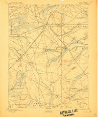
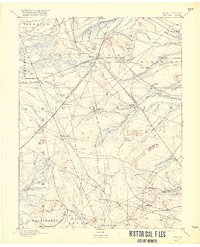
1888 Map of Whitings
USGS Topo · Published 1900About this map
Whitings emerges as a vital railroad junction in the late nineteenth century, serving as the intersection for the Philadelphia and Long Branch Railroad, the New Jersey Southern Railroad, and the Tuckerton Railroad. This convergence of rail lines facilitated the transport of timber and iron products from the surrounding Pine Barrens. The landscape is dotted with evidence of early industry and habitation, including the Union Clay Works, Dover Forge, and numerous milling operations such as Giberson Mills and Wells Mills.
Find a feature on this map
68 named features on this map. Tap any name to fly to it.
Don’t see what you’re looking for? This feature index may not catch every label — zoom into the map to look around manually.
Map Details
Editions of this 1888 Whitings Map
3 editions found
Other maps of this area

1884 · Whitings
USGS Topo · 1:62,500

1888 · Bordentown
USGS Topo · 1:62,500

1888 · Pemberton
USGS Topo · 1:62,500

1888 · Barnegat
USGS Topo · 1:62,500

1888 · Little Egg Harbor
USGS Topo · 1:62,500

1888 · Asbury Park
USGS Topo · 1:62,500

1888 · Cassville
USGS Topo · 1:62,500

1888 · Long Beach
USGS Topo · 1:62,500

1890 · Mullica
USGS Topo · 1:62,500

1893 · Bordentown
USGS Topo · 1:62,500