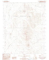
1989 Map of Senator Mountain NW
USGS Topo · Published 1990About this map
White Hills dominate the central topography of this Mohave County region, forming a prominent north-south ridge system that dictates the flow of local drainage. Much of this arid landscape is protected within the Lake Mead National Recreation Area, where the terrain transitions from the high point at Squaw Peak down into the expansive Detrital Wash to the west. This 1989 provisional edition, based on earlier surveys by the U.S. Geological Survey, illustrates the sparse infrastructure characteristic of the high desert, primarily consisting of four-wheel-drive trails and the established Temple Bar Road which provides access toward the shoreline of Lake Mead to the north. Geologists and local researchers will find the detailed contour intervals useful for tracing the complex alluvial fans and erosional patterns that define this section of the Arizona desert.
Find a feature on this map
8 named features on this map. Tap any name to fly to it.
Don’t see what you’re looking for? This feature index may not catch every label — zoom into the map to look around manually.
Map Details
Editions of this 1989 Senator Mountain NW Map
This is the sole edition of this map. No revisions or reprints were ever made.
Other maps of this area

1886 · Camp Mohave
USGS Topo · 1:250,000

1886 · Saint Thomas
USGS Topo · 1:250,000

1892 · Camp Mohave
USGS Topo · 1:250,000

1893 · Saint Thomas
USGS Topo · 1:250,000

1926 · Nelson
USGS Topo · 1:96,000

1926 · Bonelli
USGS Topo · 1:96,000

1926 · Boulder Canyon
USGS Topo · 1:96,000

1942 · Camp Mohave
USGS Topo · 1:250,000

1947 · Kingman
USGS Topo · 1:250,000

1948 · Kingman
USGS Topo · 1:250,000