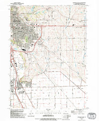
1993 Map of Sergeant Bluff
USGS Topo · Published 1995About this map
Sergeant Bluff and the expanding south side of Sioux City are captured here during a period of significant suburban and commercial growth. The landscape is defined by the transition from the dense residential grid of Morningside, home to Morningside College and several historic schools like McKinley Sch, to the newer commercial developments around the Southern Hills Mall. To the south, the Missouri River floodplain is guarded by a large Levee, while the uplands are marked by several large memorial grounds including Graceland Park Cemetery and Memorial Park Cemetery. Industrial and transit history is visible in the corridor of the Chicago and North Western railroad and an Old Railroad Grade that cuts through the southern fields. The drainage of the area is managed by a network of waterways including Dead Man Creek and the Farmers Ditch, reflecting the engineering required for both agricultural and urban stability in this river valley environment.
Find a feature on this map
73 named features on this map. Tap any name to fly to it.
Don’t see what you’re looking for? This feature index may not catch every label — zoom into the map to look around manually.
Map Details
Editions of this 1993 Sergeant Bluff Map
This is the sole edition of this map. No revisions or reprints were ever made.
Other maps of this area

1955 · Sioux City
USGS Topo · 1:250,000

1958 · Sioux City
USGS Topo · 1:250,000

1959 · Sioux City
USGS Topo · 1:250,000

1962 · Union Center
USGS Topo · 1:62,500

1963 · Sioux City South
USGS Topo · 1:24,000

1963 · Sioux City North
USGS Topo · 1:24,000

1964 · Sergeant Bluff
USGS Topo · 1:24,000

1964 · James
USGS Topo · 1:24,000

1964 · Lawton
USGS Topo · 1:24,000

1964 · Luton
USGS Topo · 1:24,000