
1981 Map of Sharon
USGS Topo · Published 1989About this map
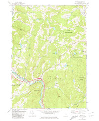
The White River and its winding tributaries, including the First Branch White River and Broad Brook, dominate the landscape of Windsor and Orange Counties as it appeared in the early 1980s. The village of Sharon serves as a focal point along the river bend, intersected by the Central Vermont railroad line. Significant cultural landmarks include the Joseph Smith Monument near the Royalton border and a historic Covered Bridge crossing near the north edge of the map. High elevations such as Quimby Mtn and Baxter Mtn overlook a mix of conservation and agricultural lands, notably the White River Wildlife Management Area and the Charles Downer State Forest. This survey captures the rural character of the region, where family-named cemeteries like Button Cem and Robinson Cem dot the hillsides, alongside traditional infrastructure like the Gravel Pits and the remote network of farm and dairy roads.
Find a feature on this map
56 named features on this map. Tap any name to fly to it.
Don’t see what you’re looking for? This feature index may not catch every label — zoom into the map to look around manually.
Map Details
Editions of this 1981 Sharon Map
2 editions found
Historical Maps of Norwich Through Time
49 maps found

1906 Hanover
Windsor County, VT

1908 Hanover
Windsor County, VT

1911 Woodstock
Windsor County, VT

1913 Woodstock
Windsor County, VT

1919 Royalton
Windsor County, VT

1924 Randolph
Windsor County, VT

1926 Randolph
Windsor County, VT

1928 Ludlow
Windsor County, VT

1929 Ludlow
Windsor County, VT

1932 Ludlow
Windsor County, VT

1943 Woodstock
Windsor County, VT

1957 Randolph
Windsor County, VT

1959 Hartland
Windsor County, VT

1966 Delectable Mountain
Windsor County, VT

1966 Plymouth
Windsor County, VT

1966 Woodstock North
Windsor County, VT

1966 Woodstock South
Windsor County, VT

1970 Rochester
Windsor County, VT

1971 Andover
Windsor County, VT

1971 Ludlow
Windsor County, VT

1972 Cavendish
Windsor County, VT

1972 Chester
Windsor County, VT

1976 Woodstock North
Windsor County, VT

1980 Bethel
Windsor County, VT
1981 Sharon
Windsor County, VT

1984 Mt. Ascutney
Windsor County, VT

1984 Springfield
Windsor County, VT

1996 Delectable Mountain
Windsor County, VT

1997 Ludlow
Windsor County, VT

1997 Rochester
Windsor County, VT

1997 Woodstock North
Windsor County, VT

1998 Hartland
Windsor County, VT

1998 Springfield
Windsor County, VT

1998 Windsor
Windsor County, VT

1998 Woodstock South
Windsor County, VT

2024 Andover
Windsor County, VT

2024 Bethel
Windsor County, VT

2024 Cavendish
Windsor County, VT

2024 Chester
Windsor County, VT

2024 Delectable Mountain
Windsor County, VT

2024 Hartland
Windsor County, VT

2024 Ludlow
Windsor County, VT

2024 Plymouth
Windsor County, VT

2024 Rochester
Windsor County, VT

2024 Sharon
Windsor County, VT

2024 Springfield
Windsor County, VT

2024 Windsor
Windsor County, VT

2024 Woodstock North
Windsor County, VT

2024 Woodstock South
Windsor County, VT