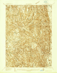
1937 Map of Shelburne Falls
USGS Topo · Published 1937About this map
The Deerfield River carves a deep path through this 1937 landscape, dictating the course of the Boston and Maine Railroad and the historic Mohawk Trail. This advance sheet reveals the transition from the industrial activity at Shelburne Falls to the agricultural pockets of Greenfield Meadows and the town of Conway. Genealogical interest is found in the numerous scattered burial grounds, such as Colrain Arms Cem and North Shirkshire Cem, which represent the early family settlements of the region. The map highlights the significant elevation changes from the Fire Tower on Massamet Mountain down to the river crossings at Reeds Bridge and Stillwater Bridge. The distribution of local landmarks like the Roberts Sch and Union Ch provides a clear view of community life in Franklin County during the late Depression era.
Find a feature on this map
61 named features on this map. Tap any name to fly to it.
Don’t see what you’re looking for? This feature index may not catch every label — zoom into the map to look around manually.
Map Details
Editions of this 1937 Shelburne Falls Map
This is the sole edition of this map. No revisions or reprints were ever made.
Other maps of this area

1885 · Northampton
USGS Topo · 1:62,500

1886 · Hawley
USGS Topo · 1:62,500

1886 · Chesterfield
USGS Topo · 1:62,500

1886 · Northampton
USGS Topo · 1:62,500

1888 · Chesterfield
USGS Topo · 1:62,500

1890 · Hawley
USGS Topo · 1:62,500

1890 · Greenfield
USGS Topo · 1:62,500

1891 · Northampton
USGS Topo · 1:62,500

1893 · Northampton
USGS Topo · 1:62,500

1893 · Chesterfield
USGS Topo · 1:62,500