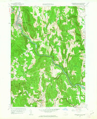
1961 Map of Shelburne Falls
USGS Topo · Published 1963About this map
Shelburne Falls serves as the focal point for this survey, where the Deerfield River bends sharply through the highlands of Franklin County. The landscape is defined by the steep relief of Massamett Mountain and Greenfield Mountain, with the corridor of the Mohawk Trail and the Boston and Maine railroad following the river's descent toward the east. This era shows a well-established network of rural infrastructure, including many family-named landmarks like Arthurs Seat and the enigmatic label The Colonel. Local genealogy is well-supported by numerous burial grounds such as Upper Meadow Cem and Pine Grove Cem, alongside small rural settlements like Burkville and Bardwell. The presence of the Aqueduct near the Arms Cem and the Stillwater Bridge downstream highlights the region's managed water resources and river crossings during the early 1960s.
Find a feature on this map
66 named features on this map. Tap any name to fly to it.
Don’t see what you’re looking for? This feature index may not catch every label — zoom into the map to look around manually.
Map Details
Editions of this 1961 Shelburne Falls Map
2 editions found
Other maps of this area

1885 · Northampton
USGS Topo · 1:62,500

1886 · Hawley
USGS Topo · 1:62,500

1886 · Chesterfield
USGS Topo · 1:62,500

1886 · Northampton
USGS Topo · 1:62,500

1888 · Chesterfield
USGS Topo · 1:62,500

1890 · Hawley
USGS Topo · 1:62,500

1890 · Greenfield
USGS Topo · 1:62,500

1891 · Northampton
USGS Topo · 1:62,500

1893 · Northampton
USGS Topo · 1:62,500

1893 · Chesterfield
USGS Topo · 1:62,500