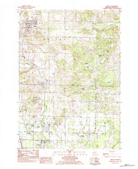
1983 Map of Shelby
USGS Topo · Published 1983About this map
The village of Shelby anchors this 1980s landscape, serving as a hub for the agricultural and forested lands of southern Oceana County. To the east, the Manistee National Forest covers much of the terrain, while the Chesapeake and Ohio railroad corridor links the primary settlements of New Era and Rothbury in a north-south line. This period shows a community balanced between small-town industry and its natural environment, with local institutions such as Our Lady of Fatima Ch, the Mennonite Ch, and the High Sch centered in the village grid.
Find a feature on this map
59 named features on this map. Tap any name to fly to it.
Don’t see what you’re looking for? This feature index may not catch every label — zoom into the map to look around manually.
Map Details
Editions of this 1983 Shelby Map
This is the sole edition of this map. No revisions or reprints were ever made.
Other maps of this area

1929 · Montague
USGS Topo · 1:48,000

1931 · Hart NW
USGS Topo · 1:31,680

1931 · Hart SE
USGS Topo · 1:31,680

1931 · Hart NE
USGS Topo · 1:31,680

1931 · Walkerville SW
USGS Topo · 1:31,680

1931 · Walkerville NW
USGS Topo · 1:31,680

1954 · Milwaukee
USGS Topo · 1:250,000

1958 · Milwaukee
USGS Topo · 1:250,000

1958 · Hesperia
USGS Topo · 1:62,500

1958 · Twin Lake
USGS Topo · 1:62,500