2024 Map of Sheldon
USGS Topo · Published 2024About this map
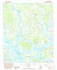
Yemassee and Sheldon anchor a coastal South Carolina landscape defined by the complex waterways of the Lowcountry. The Broad River and its numerous tidal tributaries, including the Pocotaligo River and Huspa Creek, create a fragmented terrain of necks and islands. Large landholdings like Mackay Point and Brays Island are surrounded by a network of creeks such as Haulover Creek and Whale Branch. This modern survey illustrates the persistent importance of the Trask Pkwy corridor, which connects local centers like Gardens Corner and Seabrook. The boundary between Jasper County and Beaufort County follows the winding path of the Pocotaligo River, reflecting how natural watercourses historically dictated local political divisions in the salt marsh environment.
Find a feature on this map
116 named features on this map. Tap any name to fly to it.
Don’t see what you’re looking for? This feature index may not catch every label — zoom into the map to look around manually.
Map Details
Editions of this 2024 Sheldon Map
This is the sole edition of this map. No revisions or reprints were ever made.