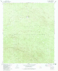
1979 Map of Sil Nakya
USGS Topo · Published 1979About this map
Sil Nakya sits at the heart of the Papago Indian Reservation in Pima County, serving as a primary settlement node during the mid-1970s. The landscape is defined by the elevation changes of the North Comobabi Mountains and the Sil Nakya Hills, where the seasonal Sil Nakya Wash cuts through the desert terrain. Water access is critical in this environment, evidenced by named sites such as Nawt Vaya Well and Frog Well scattered across the Sil Nakya Valley. Religious and communal life centers on the St Agatha Mission, accompanied by two local Cem sites. This survey records a network of primitive transportation, including a Jeep Trail and various Trail segments that connect the settlement to outlying landmarks like Mt Devine and isolated prospects. Distinctive markers such as Edn Hugham Sunday and several Uslm stations provide valuable coordinates for local historical research.
Find a feature on this map
22 named features on this map. Tap any name to fly to it.
Don’t see what you’re looking for? This feature index may not catch every label — zoom into the map to look around manually.
Map Details
Editions of this 1979 Sil Nakya Map
This is the sole edition of this map. No revisions or reprints were ever made.
Other maps of this area

1934 · Silver Bell
USGS Topo · 1:125,000

1937 · Comobabi
USGS Topo · 1:48,000

1938 · San Vicente
USGS Topo · 1:62,500

1941 · San Vicente
USGS Topo · 1:62,500

1942 · San Vicente
USGS Topo · 1:62,500

1942 · Comobabi
USGS Topo · 1:62,500

1948 · San Vicente
USGS Topo · 1:62,500

1956 · Tucson
USGS Topo · 1:250,000

1958 · Tucson
USGS Topo · 1:250,000

1959 · Tucson
USGS Topo · 1:250,000
Featured Places
- Gu Achi District, AZ
- Schuk Toak District, AZ
- Sil Nakya, Schuk Toak District
- Pima County, AZ
- United States