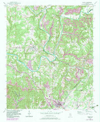
1949 Map of Sipsey
USGS Topo · Published 1983About this map
The Sipsey Fork Mulberry Fork and Mulberry Fork dictate the settlement and transport patterns of this Walker County landscape. The winding river system forms dramatic oxbows such as Magbee Bend and Burton Bend, while the surrounding terrain is marked by industrial activity, including a Strip Mine and multiple Mine Dump sites. These features underscore the region's reliance on the coal and river economy during the mid-20th century.
Find a feature on this map
58 named features on this map. Tap any name to fly to it.
Don’t see what you’re looking for? This feature index may not catch every label — zoom into the map to look around manually.
Map Details
Editions of this 1949 Sipsey Map
5 editions found

Other maps of this area

1889 · Birmingham
USGS Topo · 1:125,000

1892 · Birmingham
USGS Topo · 1:125,000

1893 · Jasper
USGS Topo · 1:125,000

1895 · Birmingham
USGS Topo · 1:125,000

1904 · Birmingham Coal District
USGS Topo · 1:62,500

1906 · Birmingham Special
USGS Topo · 1:62,500

1907 · Birmingham
USGS Topo · 1:125,000

1935 · Port Birmingham
USGS Topo · 1:48,000

1938 · Port Birmingham
USGS Topo · 1:62,500

1949 · Cordova
USGS Topo · 1:24,000