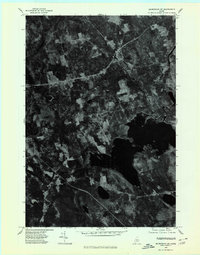
1975 Map of Skowhegan NE
USGS Topo · Published 1980About this map
Harmony and the nearby settlement of Mainstream anchor this orthophotograph, which provides a detailed overhead view of central Maine during the mid-1970s. The landscape is defined by the significant expanse of Moose Pond, which dominates the lower right quadrant of the image. Winding through the northern woods and agricultural clearings is the Sebasticook River, its path clearly visible against the dense timber and patchworked fields. Because this is an orthophotomap rather than a traditional line-drawing, it reveals the specific texture of the land—differentiating between evergreen stands, deciduous growth, and the small-scale family farms that have historically sustained this portion of Somerset County. The distribution of clearings around the primary roads suggests a rural economy tied closely to the natural resources of the river valley and the shoreline of the pond.
Find a feature on this map
4 named features on this map. Tap any name to fly to it.
Don’t see what you’re looking for? This feature index may not catch every label — zoom into the map to look around manually.
Map Details
Editions of this 1975 Skowhegan NE Map
This is the sole edition of this map. No revisions or reprints were ever made.
Other maps of this area

1913 · Skowhegan
USGS Topo · 1:62,500

1930 · Pittsfield
USGS Topo · 1:48,000

1932 · Pittsfield
USGS Topo · 1:62,500

1933 · Pittsfield
USGS Topo · 1:62,500

1933 · Guilford
USGS Topo · 1:62,500

1937 · Guilford
USGS Topo · 1:62,500

1948 · Bangor
USGS Topo · 1:250,000

1948 · Kingsbury
USGS Topo · 1:62,500

1950 · Kingsbury
USGS Topo · 1:62,500

1954 · Millinocket
USGS Topo · 1:250,000