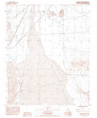
1983 Map of Soda Lake North
USGS Topo · Published 1984About this map
Zzyzx sits on the western edge of the expansive Soda Lake (Dry), a landscape defined by desert hydrology and early transit corridors. This 1983 survey documents the arid basin between the Soda Mountains and Cowhole Mtn, where water is a rare presence marked by a Spring and a southern Marsh. The infrastructure of the Mojave is preserved here through the Tidewater & Tonopah RR (Grade) and the Old Government Historic Trail, which cuts across the dry lake bed. Local industry is represented by a scattered Mine and Mine Shaft near the eastern peaks. The map also records mid-century utilities, including an Underground Gas Pipeline and a long Fence Line stretching across the northern flats near Hanks Mountain.
Find a feature on this map
20 named features on this map. Tap any name to fly to it.
Don’t see what you’re looking for? This feature index may not catch every label — zoom into the map to look around manually.
Map Details
Editions of this 1983 Soda Lake North Map
2 editions found
Other maps of this area

1910 · Ivanpah
USGS Topo · 1:250,000

1912 · Ivanpah
USGS Topo · 1:250,000

1933 · Avawatz Mountains
USGS Topo · 1:250,000

1942 · Ivanpah
USGS Topo · 1:250,000

1947 · Trona
USGS Topo · 1:250,000

1947 · Kingman
USGS Topo · 1:250,000

1948 · Kingman
USGS Topo · 1:250,000

1948 · Trona
USGS Topo · 1:250,000

1953 · Trona
USGS Topo · 1:250,000

1954 · Kingman
USGS Topo · 1:250,000