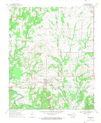
1968 Map of Soper
USGS Topo · Published 1971About this map
Soper and its surrounding rural townships of Oakes and Hunter dominate this late 1960s survey of Choctaw County. The St Louis - San Francisco railroad cuts a straight path east-to-west across the landscape, serving the small community and its adjacent Soper Cemetery. To the north, the small settlement of Kent is anchored by Kent Church, while Jasper sits at the western edge of the rail line. The terrain is defined by a dense network of waterways including Sugar Creek, Beaverdam Creek, and the larger Muddy Boggy Creek to the southwest. Unusual local landmarks like the Fish Hatchery near the northern boundary and a Roadside Park along the highway reflect the mid-century development of this portion of southeastern Oklahoma, where agricultural fields are partitioned by miles of checked fence lines.
Find a feature on this map
20 named features on this map. Tap any name to fly to it.
Don’t see what you’re looking for? This feature index may not catch every label — zoom into the map to look around manually.
Map Details
Editions of this 1968 Soper Map
This is the sole edition of this map. No revisions or reprints were ever made.
Other maps of this area

1901 · Antlers
USGS Topo · 1:125,000

1903 · Paris
USGS Topo · 1:125,000

1912 · Antlers
USGS Topo · 1:125,000

1925 · Antlers
USGS Topo · 1:125,000

1948 · Grant
USGS Topo · 1:62,500

1948 · Direct
USGS Topo · 1:62,500

1949 · Direct
USGS Topo · 1:62,500

1949 · Grant
USGS Topo · 1:62,500

1950 · Mcalester
USGS Topo · 1:250,000

1953 · Texarkana
USGS Topo · 1:250,000